

Updated March 2026 — Arkansas earns its nickname. The Natural State is home to some of the most rewarding day hikes in the entire mid-South, from canyon-carved hollows in the Ozarks to high bluff rims above the Arkansas River Valley. We asked our readers to name their single favorite day hike, and the results were clear: Buffalo National River country and Arkansas State Parks dominate the list. These are the trails you voted to the top, updated with the latest trail conditions and tips for 2026.
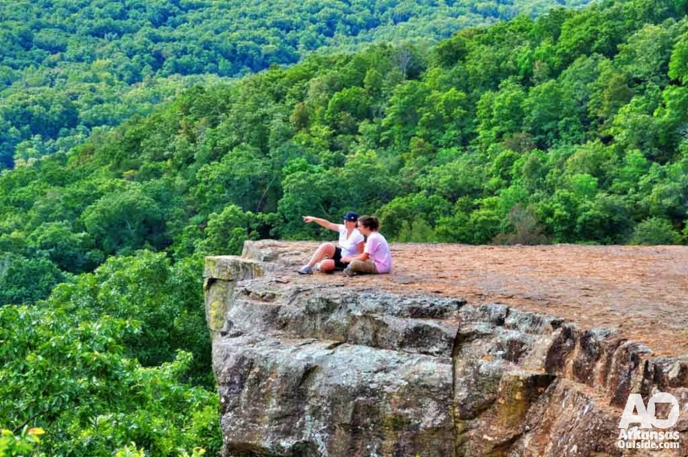
#5 (Tie) — North Rim Trail, Mount Magazine State Park (6.15% of votes)
Location: Paris, AR | Distance: 2.2 miles one-way | Difficulty: Moderate
Signal Hill may be the highest point in Arkansas at 2,753 feet, but its summit is heavily forested with limited views. The nearby North Rim Trail makes up for that in every way. Starting at the park visitor center and tracing the north edge of the mountain for 2.2 miles, this path delivers sweeping views of the Arkansas River Valley from the top of dramatic bluffs. It’s the kind of panoramic reward that justifies every step.
Watch young children carefully, the trail runs along exposed bluff edges with significant drop-offs. If you’d rather not retrace your steps, cross the road at the western end to pick up the Mossback Ridge Trail and complete a full 4.4-mile loop back to the visitor center. The park’s full amenity package, camping, cabins, a lodge, restaurant, and a network of additional trails, makes this an ideal overnight destination too.
Pro tip: Visit in October when the hardwoods along the bluff line turn gold and orange. The contrast against the valley below is spectacular.
#5 (Tie) — Yellow Rock Trail, Devil’s Den State Park (6.15% of votes)
Location: West Fork, AR | Distance: 5–6 mile loop | Difficulty: Moderate | Best in: Fall
Devil’s Den is one of Arkansas’s most beloved state parks, and the Yellow Rock Trail is its crown jewel. From the campground trailhead, the path winds past boulders and beneath soaring bluffs on a gradual climb to the Yellow Rock Overlook, a sandstone promontory with breathtaking views of the Lee Creek Valley and the surrounding Boston Mountains. It’s a particularly vivid destination in fall when the tree canopy ignites.
After taking in the overlook, the trail loops down past one of Arkansas’s oldest CCC-built structures before delivering a final view of Devil’s Den Lake and the park below. The total loop clocks in at five to six miles. Families with younger children should consider the shorter Devil’s Den Trail instead, which winds through crevices and past caves for a memorable, low-mileage adventure.
Note: The park offers historic stone cabins built by the Civilian Conservation Corps in the 1930s — worth booking well ahead if you want to extend your visit.
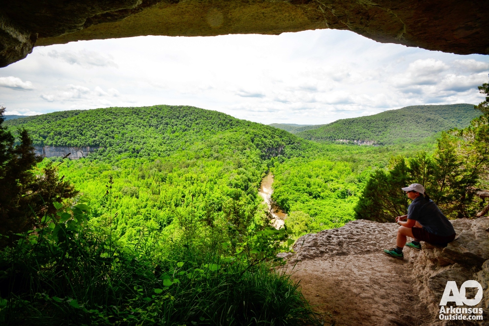
#5 (Tie) — Big Bluff / Goat Trail, Buffalo Wilderness Area (6.15% of votes)
Location: Near Ponca, AR | Distance: ~4 miles out-and-back | Difficulty: Moderate–Strenuous | Dogs: Not permitted
Few hikes anywhere in the Ozarks can match the raw drama of the Goat Trail at Big Bluff. From the Centerpoint Trailhead, a manageable descent leads out onto the face of one of the tallest river bluffs in the United States, a narrow ledge hundreds of feet above a bend in the Buffalo River. The views of America’s first National River curving through its ancient valley are genuinely awe-inspiring.
This is not a hike for those with a fear of heights, and younger children should be kept close on the exposed sections. For a longer day, continue down to the Buffalo River and follow it downstream to Hemmed-In Hollow, home to the tallest waterfall between the Rockies and Appalachians, best experienced after good rainfall. The return hike from the river is almost entirely uphill, so pace yourself accordingly. Dogs are not permitted in the Buffalo Wilderness Area.
Timing: Spring and fall offer the best conditions. Summer heat and humidity make the uphill return considerably more demanding.
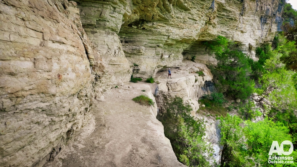
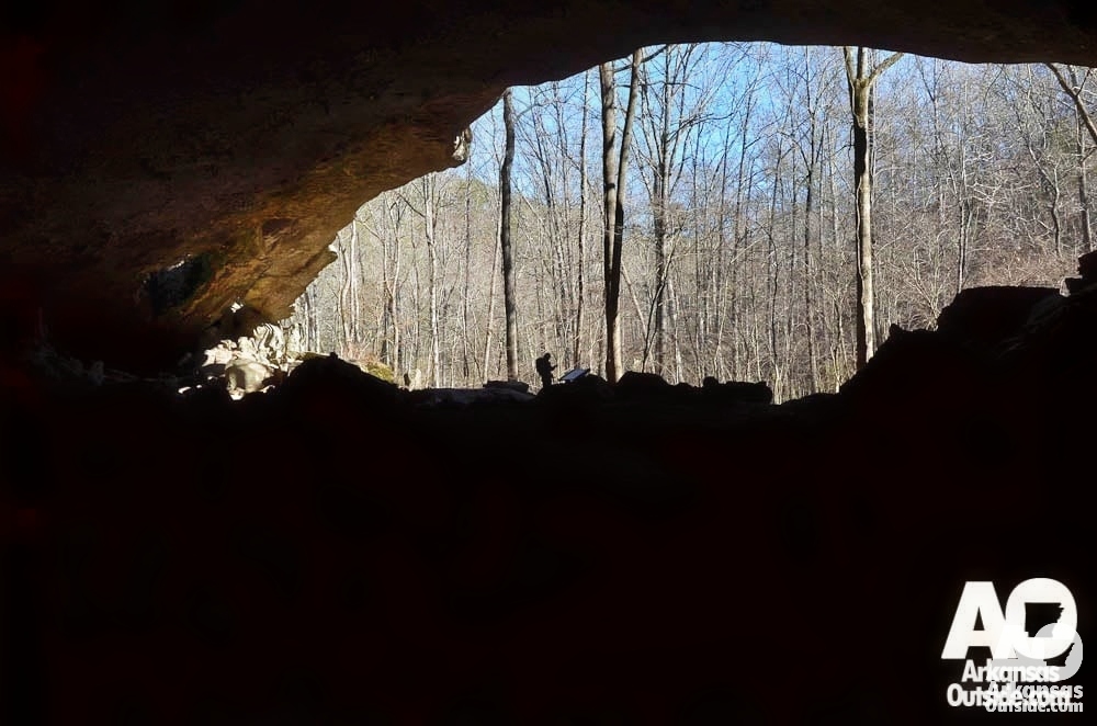
#4 (Tie) — Lost Valley Trail, Buffalo National River (7.69% of votes)
Location: Near Ponca, AR (Hwy 43) | Distance: 2.3 miles out-and-back | Difficulty: Easy–Moderate | Status: Open
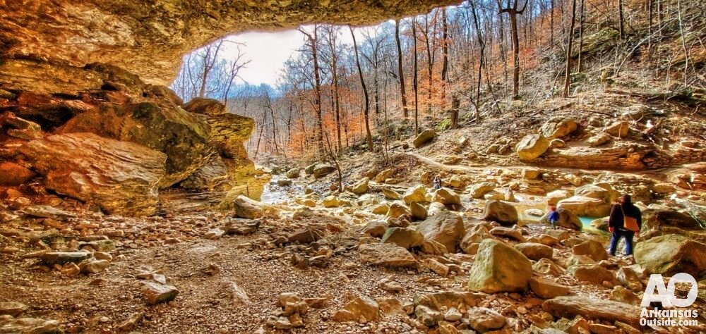
Lost Valley is among the most beloved short hikes in the entire state, and it’s earned that reputation. The 2.3-mile out-and-back trail winds up a box canyon along Clark Creek, passing beneath American beech groves before delivering a remarkable sequence of geological features: a natural limestone bridge, the massive 200-foot overhang of Cob Cave, and the trail’s crown jewel — Eden Falls, a 53-foot cascade plunging into a clear pool.
For the adventurous, a steep spur trail continues beyond Eden Falls to a 200-foot cave with a hidden 25-foot waterfall inside. Bring a headlamp and wear sturdy shoes with good grip, the cave floor is slippery. This is the most popular hike in the entire Buffalo National River, so arrive early on weekends, especially in spring and fall. The trail is designated a high Search & Rescue area; slippery rocks demand careful footing throughout.
The Boxley Valley elk herd is frequently visible in fields near the trailhead parking area, another reason to arrive at dawn.
Best time to visit: Spring, when snowmelt keeps Eden Falls running full. Summer can reduce the flow to a trickle, though the canyon scenery remains beautiful year-round.
#4 (Tie) — Indian Rock House Nature Trail, Buffalo National River — Buffalo Point (7.69% of votes)
Location: Buffalo Point, AR | Distance: ~1.5 miles | Difficulty: Easy–Moderate
Buffalo Point, once part of the Arkansas State Park system and now managed by the National Park Service, is a remarkable place to absorb multiple layers of Ozark history in a single short hike. The Indian Rock House Nature Trail passes through eras spanning thousands of years, beginning with a massive bluff shelter that served as a site for prehistoric Native American use.
Further along the trail, hikers encounter the entrance to an old zinc mine, a reminder of early 20th-century efforts by settlers to find economic footing in these rugged hills. Near the trail’s end, a rock quarry used by the Civilian Conservation Corps in the 1930s comes into view. It’s a relatively short and accessible hike, but the historical depth it covers is extraordinary.
Combine it: Buffalo Point also offers camping and cabin rentals with easy access to the river. Make a weekend of it.
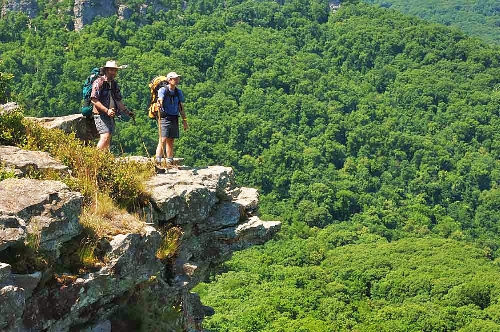
#2 — Whitaker Point Trail (Hawksbill Crag), Upper Buffalo Wilderness (9.23% of votes)
Location: Near Boxley, AR | Distance: ~2.8 miles out-and-back | Difficulty: Moderate
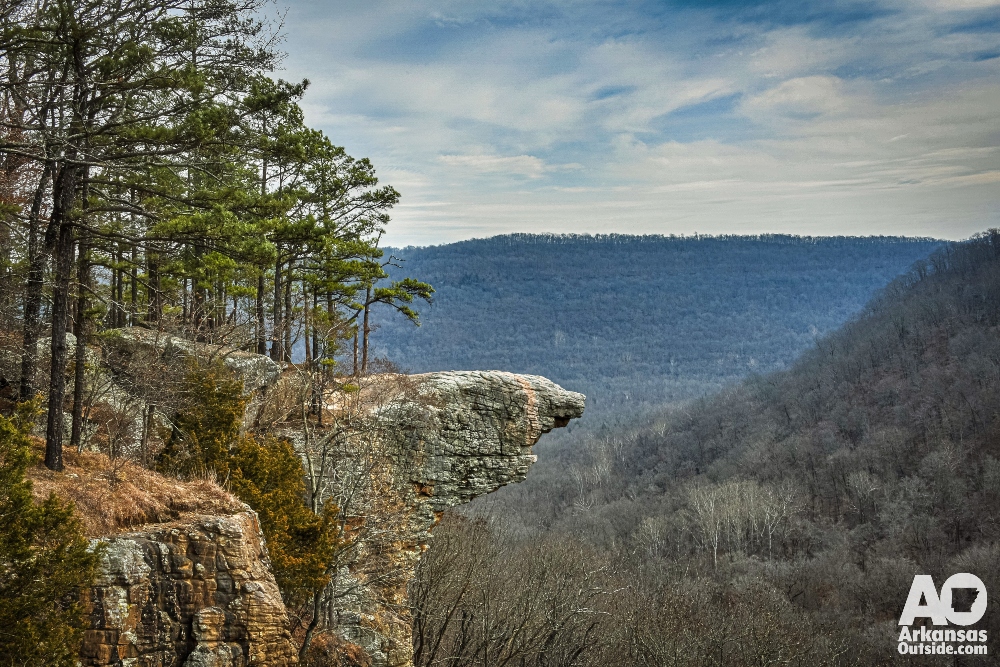
If there’s one image people picture when they think of hiking in Arkansas, it’s often Hawksbill Crag, the narrow sandstone promontory jutting dramatically above the Upper Buffalo Wilderness. This is one of the truly iconic landscapes in the state, and the Whitaker Point Trail firmly belongs on every Arkansas hiker’s bucket list.
The trail begins with a gentle downhill through the woods, passing a small seasonal waterfall before turning to follow the bluff line. Exercise caution here, the rocks are slippery near the edges and the drop is severe. As you continue, glimpses of the Crag appear through the trees before the trail opens onto the full dramatic view. The hike back is a gradual uphill. There are no facilities in the area, so come fully supplied with water and food.
Crowds: Hawksbill Crag has become widely photographed and draws heavy traffic on fall weekends. Weekday mornings in spring offer a far more solitary experience.
#1 — Seven Hollows Trail, Petit Jean State Park (29.23% of votes)
Location: Morrilton, AR | Distance: ~4.5-mile loop | Difficulty: Moderate
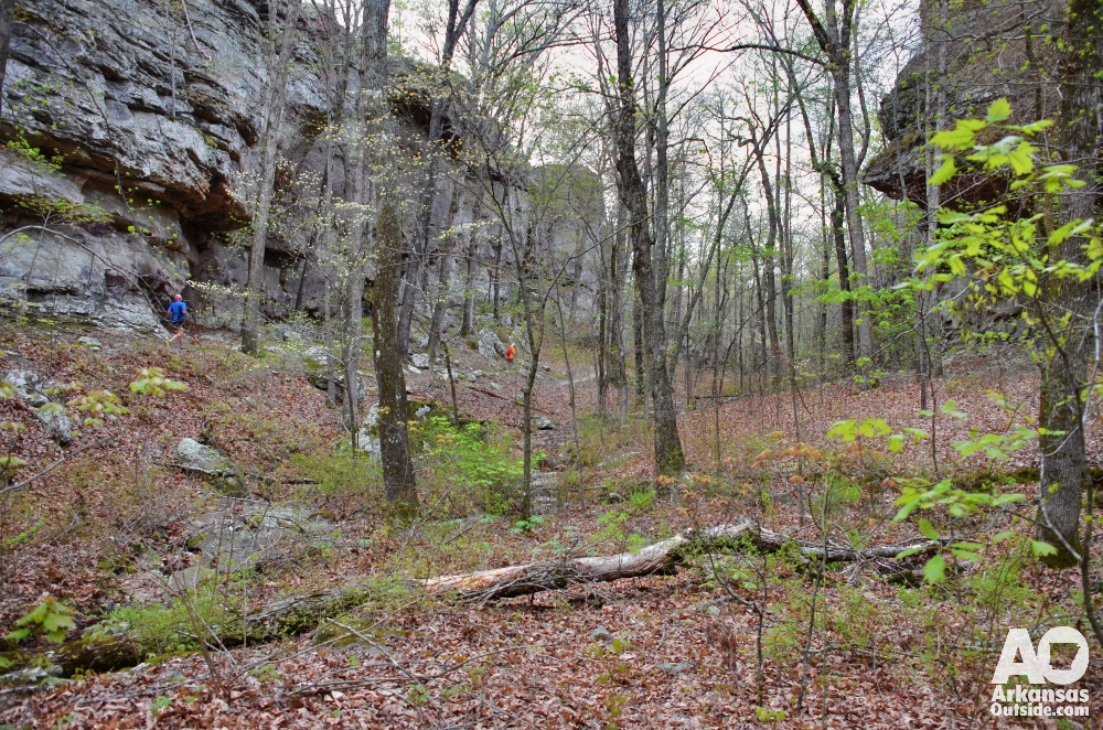
Seven Hollows won our reader poll by a commanding margin, nearly 30% of all votes, and it’s not hard to understand why. This is one of the most geologically and scenically varied hikes in the state, located in the area whose rugged terrain was deemed too difficult for commercial logging and ultimately gave rise to the Arkansas State Park system itself.
The trail descends from the south rim of Petit Jean Mountain into a series of deep hollows packed with features. Take the first left and you’ll drop into a canyon holding a stunning natural stone arch. Just beyond is “Turtle Rocks,” a cluster of rounded sandstone formations that look remarkably like turtle shells emerging from the ground. The trail then swings west into an adjacent hollow where a short spur leads north to The Grotto, a sheltered alcove beneath a rock overhang with a small waterfall and a clear plunge pool. It’s one of the best picnic spots in the state.
As the trail turns north and heads back toward the trailhead, the path narrows through a slot-like passage with small caves tucked into the walls on either side. The full loop is about 4.5 miles and takes a solid two to three hours. Plan extra time, Petit Jean’s lodge, restaurant, overlooks, and Cedar Falls trail all deserve a visit while you’re there.
Stay over: Mather Lodge at Petit Jean is one of the finest historic lodges in any state park system in the country. Book a room and make a full weekend of the park’s many trails and overlooks.
Get Out There
These seven trails represent the best of what Arkansas has to offer on foot, but they’re just the beginning. The state’s 52 state parks, the Buffalo National River, and the Ozark and Ouachita National Forests hold hundreds of miles of trail waiting to be explored. Check conditions before you go, pack plenty of water, and leave no trace. Arkansas rewards those who show up.

Find more trail information at Buffalo National River and Arkansas State Parks.
This article was originally published on ArkansasOutside.com, your trusted source for outdoor news and updates in The Natural State. Unless otherwise credited, all photos included in this piece are the property of Arkansas Outside, LLC. We take pride in sharing the beauty and adventures of Arkansas through our lens—thank you for supporting our work!