
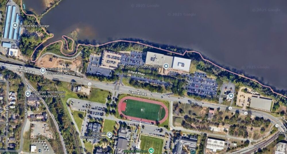


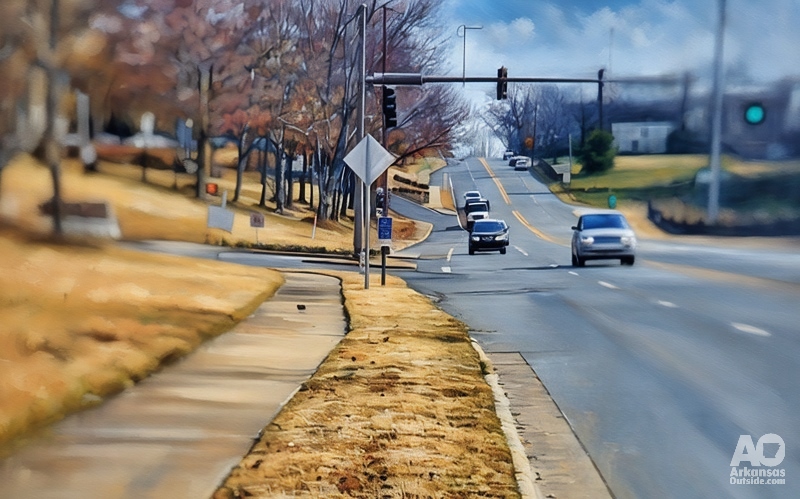
For over two decades, the Arkansas River Trail in Central Arkansas has been touted as a recreational gem; yet, the “loop” remains incomplete. A dangerous gap along Cantrell Road in Little Rock forces cyclists and pedestrians off the protected trail and onto a cramped sidewalk sandwiched between Episcopal Collegiate School and Dillard’s corporate headquarters. This four-lane stretch of Cantrell (State Highway 10) carries about 23,000 vehicles on an average weekday, making the detour harrowing for trail users. Closing this gap, the “Close the Loop” project, has once again become a focal point for city officials and trail advocates eager to make the River Trail a continuous, safe loop. Recent articles, such as this month’s cover article in the Arkansas Times, have contributed to the call to complete this section of the trail.
Stalled Plans and New Negotiations with Dillard’s
The infamous “Dillard’s gap” has long stymied Little Rock. The most obvious route for the trail would have crossed Dillard’s property, but the company resisted all proposals for over 15 years. At one point, around 2010, negotiations grew so tense that Dillard’s reportedly threatened to move its headquarters out of town if the city attempted to use eminent domain to run the trail through its campus. In short, previous mayors and advocates found themselves “between a rock and a hard place,” as local cyclists put it, unable to secure an agreement with the private landowners.
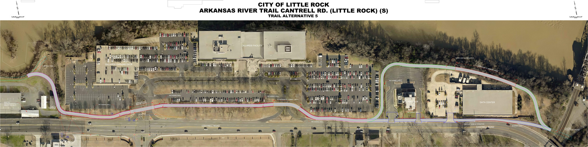
Now, under Mayor Frank Scott Jr., there are signs of progress. The city hired Garver Engineering to devise several alternative designs for bridging the gap. Last year, five different plans ranging from an improved sidepath along the road to a standalone pedestrian bridge or even a tunnel under part of the Dillard’s property were presented to the Bicycle Advocacy of Central Arkansas (BACA) for feedback. The most popular concept among cyclists was “Option 5,” a hybrid plan proposing a bridge over one of Dillard’s driveways and a tunnel under another, with the trail routed behind an adjacent private club and a Dillard’s IT building. These plans (all drawn up by Garver) show that engineering solutions do exist, but they still require Dillard’s buy-in and funding to become a reality.
City officials are currently waiting on another meeting with Dillard’s leadership to review and hopefully finalize one of these plans. After years of being unable even to get Dillard’s to the table, Little Rock leaders managed to hold at least one “positive and productive” meeting with the company in June 2025 and expect to meet again soon. The hope is that Dillard’s will approve an alignment for the trail through this corridor, allowing the final design and right-of-way agreements to move forward. Essentially, the city needs Dillard’s cooperation to finalize the deal and close the loop.
Funding Hurdles and Calls for Public-Private Partnership
Even if a route is agreed upon, paying for the project remains a significant challenge. Mayor Scott recently acknowledged that the city currently lacks the funding to construct the River Trail connector through the Dillard’s area. Money was allocated for the preliminary engineering design (a $170,200 contract, which has been covered), but no dollars are lined up for construction of the trail itself. This stark funding gap means that, at present, the biggest obstacle to closing the loop isn’t land access or engineering, it’s financing.
When meeting with local bike advocates in July, Mayor Scott indicated that he would prefer a public-private solution to fund the trail segment, rather than relying solely on government grants. He “had no money actually to complete the project… and hoped that we could find some people with deep pockets that could help pay for it,” according to BACA vice-president Joe Jacobs, who met with the mayor. In other words, the mayor is seeking private investors, corporate partners, or philanthropists to help cover the costs of this section of the trail, rather than relying on federal or state grants. So far, however, no private funding has been secured or publicly announced. This leaves the project in a bit of limbo: the city is interested in a public-private partnership model, but it has not yet identified who those deep-pocketed partners might be.
(Local trail proponents have noted that in Northwest Arkansas, generous support from the Walton Family Foundation helped build an extensive trail network, whereas in Central Arkansas, such private investment has been lacking. This contrast underscores why Little Rock officials are now casting about for private-sector help to close their trail loop, finally.)
The Unfinished Medical Mile Connection
As the Dillard’s gap effort inches forward, another incomplete piece of the Arkansas River Trail is also drawing attention. On the downtown end of the trail – the Medical Mile portion – a final link between the River Market area and the rest of the loop remains unbuilt. Specifically, the stretch between Bruce T. Moore Way (formerly Arch Street) and the bicycle/pedestrian bridge over the Union Pacific railroad tracks (in front of the Department of Arkansas Heritage building near North Street and Cantrell Road) has yet to be completed. This missing connection is crucial for allowing trail users to travel off-street from the Clinton Presidential Park Bridge (near the River Market) all the way west to the Dillard’s area.
The city obtained grant funding for this project several years ago. In 2017, Little Rock received a $1.6 million Federal Lands Access Program (FLAP) grant to build a ramp connecting the Medical Mile to the new Bike/Ped bridge over the railroad tracks in front of the Arkansas Department of Heritage. That grant was also intended to stabilize and repair the western end of the Medical Mile, which, at the time, was starting to collapse into the Arkansas River. Together, the pedestrian overpass (completed around 2018) and the planned ramp were supposed to “complete a continuous off-street trail from the Clinton Bridge to the Dillard’s Data Center,” effectively extending the River Trail westward along downtown’s riverfront. In 2017, officials optimistically estimated that the ramp would be finished by spring 2018. The City of Little Rock’s News Release on Obtaining Funding for the Ramp.
Fast forward to 2025, and that ramp still isn’t built. The project has taken so long that the city must now conduct a second environmental assessment before work can proceed on the trail link. The environmental clearances obtained years ago have expired, and new studies are needed to account for any changes in conditions. Only after this updated review is completed can Little Rock proceed with repairing the crumbling trail section and constructing the ramp leading up to the bridge. In short, a crucial component of the Medical Mile connection, funded and approved on paper, remains unfinished on the ground, highlighting how lengthy delays can hinder even fully funded trail projects.
West Side Woes: Gill Street Bridge Construction
On the west side of the planned “Close the Loop” segment, yet another complication looms. The Gill Street bridge on Cantrell Road, which carries Hwy 10 traffic over the Union Pacific Railroad tracks, Gill Street, and Rose Creek near the Dillard’s trail gap, is slated for replacement by the Arkansas Department of Transportation (ARDOT). This highway bridge, just west of Dillard’s headquarters, is aging and due for a major overhaul as part of ARDOT’s Cantrell Road improvements.
According to ARDOT’s project plans, the new design will include a separate pedestrian bridge alongside the highway bridge to accommodate future trail users. During construction, the bridge will be built with a northern offset alignment, allowing four lanes of vehicular traffic (two in each direction) to continue flowing during peak hours. In other words, drivers on Cantrell Road should be able to get through the construction zone with minimal disruption thanks to a temporary traffic realignment.
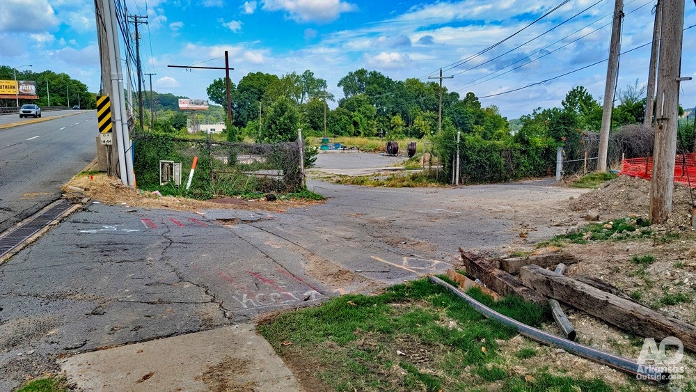
However, it’s far less clear how bicyclists and pedestrians on the Arkansas River Trail will navigate this area while the bridge work is underway. ARDOT’s maintenance-of-traffic plan calls for closing Gill Street and Water Works Road underneath the bridge during construction. The current River Trail route passes beneath the Cantrell bridge in this vicinity, meaning that if those streets are closed, the trail could effectively be blocked. The city does not yet know how the bridge project will impact the trail, and the existing trail segment near Gill Street may have to be temporarily removed during construction. To date, no specific detour or accommodation for Arkansas River Trail users has been publicized. Trail riders could face a frustrating scenario: even as the city works on closing the Dillard’s gap to make the trail continuous, the state’s bridge construction might create a new temporary gap on the west end. Local cycling advocates have expressed concern that there is no clear plan for bike/ped traffic through the area during the multi-year bridge replacement. Ensuring that trail users can safely navigate around the construction zone (perhaps via an alternate path or a protected lane) will be an essential issue as ARDOT’s project moves forward.
Why Closing the Loop Matters
All of these converging issues, negotiations with private landowners, funding shortfalls, delayed construction, and coordination with state projects, highlight why “closing the loop” on the Arkansas River Trail has been such a long-running challenge. At the same time, they underscore the significant implications for Little Rock in finally resolving this puzzle. Completing the River Trail loop would eliminate the dangerous on-street detour and create a seamless 15.6-mile pathway for recreation and active transportation. Advocates stress that a connected trail would dramatically improve safety and accessibility, inviting people of all ages and abilities to enjoy the riverfront without fear of traffic conflicts. It would link popular attractions – from the River Market and Downtown parks to Two Rivers Park and miles of greenways beyond – with a continuous, scenic route, enhancing both quality of life for residents and the city’s appeal to visitors.
There are also economic and community benefits. A fully closed loop could boost local businesses and tourism, as cyclists and pedestrians safely reach shops, restaurants, and sites along the trail. Little Rock’s civic leaders often tout the River Trail in marketing the city; in fact, images of the trail and its iconic bridges feature prominently in chamber of commerce materials to attract businesses and talent. Trail supporters argue that failing to complete the loop means missing out on an opportunity to revitalize the city further. “This is obviously a major piece of marketing for the city that brings businesses here,” Joe Jacobs noted, emphasizing that closing the gap would be a significant quality-of-life improvement for Little Rock.
After more than 20 years, will 2025 be the year Little Rock finally closes the loop? There is fresh momentum and public pressure, thanks to groups like Bicycle Advocacy of Central Arkansas and renewed attention from City Hall. Federal infrastructure and recreation grants are more plentiful now than in years past, and could potentially be tapped if local officials choose to pursue them. The pieces – engineering plans, community support, even a willing Dillard’s – seem closer to falling into place than ever before. Still, the last stretch of trail remains an “impossible dream” until funding is secured and construction actually begins.
For the general public, the recent discussions are a mix of optimism and frustration. Optimism that city leaders are actively working to solve the Dillard’s puzzle and finish the Medical Mile link, but frustration that bureaucracy, budget constraints, and timing (like the bridge project) continue to delay a project everyone agrees is worthwhile. Closing the loop matters to Central Arkansas, and residents are watching closely to see if their leaders can finally connect the dots on the map. In the end, turning this long-held dream into reality will require persistence, creative partnership, and no small amount of political will – but the payoff will be a safer, more vibrant river trail that everyone can enjoy as a true loop around the city.
Continued Park Planning and Funding
The Little Rock City Board of Directors recently approved allocating $500,000 in local funds to match a $2 million federal Reconnecting Communities Pilot Program grant, for a total of $2.5 million to fund a planning study for a deck park over Interstate 30 between 6th and 9th Streets. This study, to be conducted by Garver, LLC, will explore design options to reconnect neighborhoods divided by the freeway and determine feasibility and cost estimates for a park covering that stretch. Importantly, this project is separate from the “30 Crossing Park”, which is currently in the design phase for the area underneath I‑30 between Clinton Avenue and 4th Street, and should not be confused with the deck park initiative.
This article was originally published on ArkansasOutside.com, your trusted source for outdoor news and updates in The Natural State. Unless otherwise credited, all photos included in this piece are the property of Arkansas Outside, LLC. We take pride in sharing the beauty and adventures of Arkansas through our lens—thank you for supporting our work!

2 Responses
Way to go Mr. Dillard. You’ve single handedly managed to keep Little Rock citizens, walkers, runners, and cyclists under your old thumb for 15+ years… and counting.
I’m sure you can tell us why it was worth it.
Way to go, Mr Dillard. You’ve managed to keep Little Rock citizens including walkers, runners, cyclists, and other trail users under your thumb for 15+ years… and counting.
Please, tell us why it was worth it.