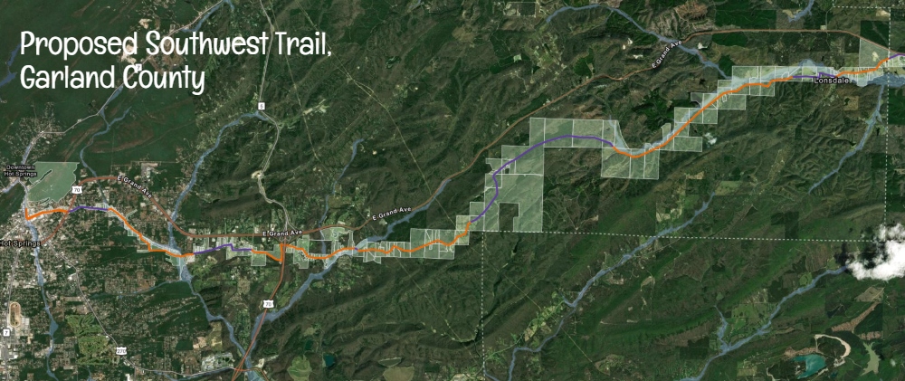


The vision for the Southwest Trail remains one of Arkansas’s most ambitious active transportation and recreation projects, a paved multiuse corridor planned to connect Hot Springs National Park to Little Rock Central High School National Historic Site. When complete, the route has often been described as a 60 to 65 mile trail stretching across central Arkansas.
While some portions farther east are already built or advancing toward construction, the Garland County segment is still largely in the planning and design stage. However, new details from City Engineer, Gary Carnahan, show that the City of Hot Springs is actively preparing its section and pursuing funding to move forward.
Why connect these two parks?
Planning for the approximately 60-mile Southwest Trail began with a major Federal Lands Access Program, or FLAP, grant awarded in June 2017 to Pulaski County, Saline County, and Garland County. One of the major criteria for being awarded this grant was that it had to connect to federal properties managed by the National Park Service.
The federal award, commonly reported at between $2.6 million and $3.2 million, funded roughly 80 percent of the early engineering, route planning, and environmental study work needed to create a continuous trail linking Hot Springs National Park with Little Rock Central High School National Historic Site. The participating counties provided the remaining 20 percent local match.
That early investment laid the groundwork for what has become one of Arkansas’s most ambitious regional trail and active transportation projects.
Garland County Still in Planning, But Progress Is Happening
Recent program management information from the Arkansas Department of Transportation lists a Garland County project simply as “Southwest Trail Design,” indicating the project is programmed rather than under construction.
That usually means engineering, route refinement, and funding preparation are underway, even if visible trail construction has not started.
According to Carnahan, the City of Hot Springs is responsible for building the Southwest Trail through city limits, while Garland County would handle the corridor from the city boundary east toward Saline County.
How the Trail Would Enter Hot Springs
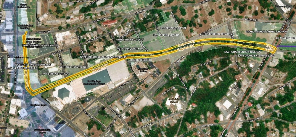
Carnahan said the trail is planned to enter downtown Hot Springs near the historic transportation depot and Convention Boulevard.
The route would use existing bike lanes on Convention Boulevard, then turn north on Malvern Avenue to a planned trailhead near the Hot Springs National Park Headquarters on Reserve Street. That area is envisioned as a gathering point for rides, races, and group events.
From there, users would connect back toward Convention Boulevard and continue onto the Hot Springs Creek Greenway, which already extends toward Lake Hamilton and a kayak launch area.
Funding Secured for First City Segment
Carnahan said Hot Springs has secured a FLAP grant, short for Federal Lands Access Program, to build the first half of the city’s Southwest Trail section.
That initial project would cover roughly 1.5 miles from Reserve Street near the National Park Headquarters to the Spring Street area. Portions would include refreshed bike lanes, new bike lanes, and sections of separated off-street trail.
The city has also applied for an additional BUILD grant to complete the remaining portion inside city limits.
Carnahan said current federal funding schedules point to construction beginning around 2028 for the first segment.
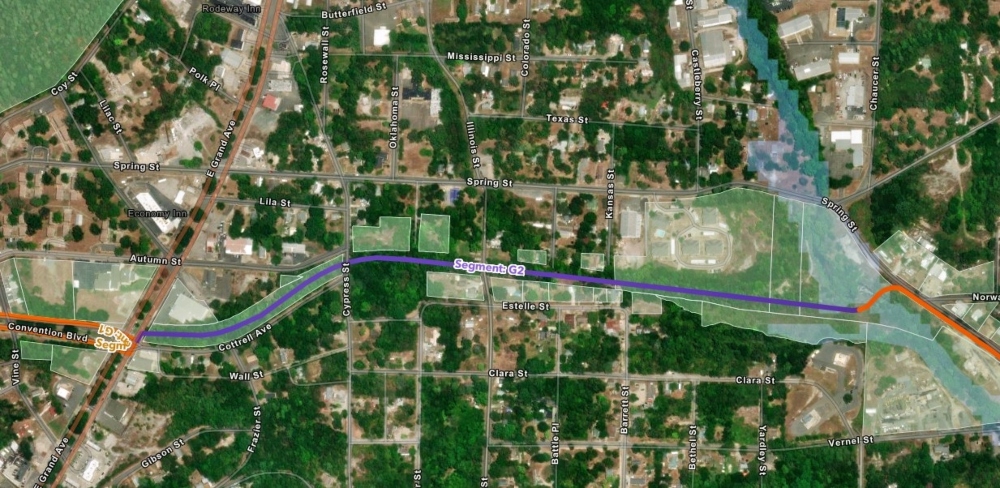
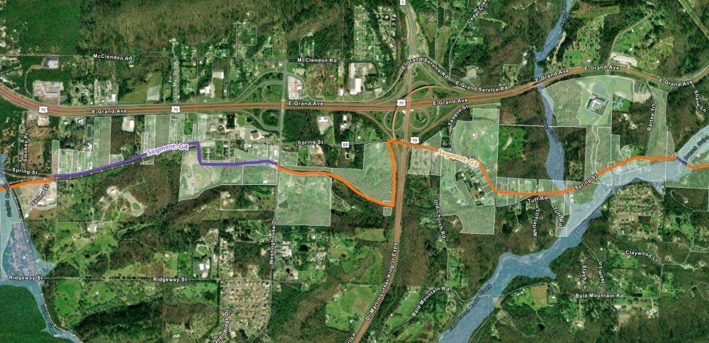
County Segment Toward Saline County
Carnahan also said Garland County has funding in hand for a segment extending from the city limits east toward the MLK Bypass area. He said design work is complete and right-of-way acquisition is underway.
A second grant has also reportedly been secured to continue farther east toward Saline County, though final limits and mileage were not immediately available.
Separate Greenways Also Building Momentum
Garland County and Hot Springs continue to develop local trail systems outside the Southwest Trail corridor, including the Hot Springs Creek Greenway and Stokes Creek Greenway.
Those projects improve local connectivity now and could become important feeders into the regional Southwest Trail network in the future.
Bottom Line
The Southwest Trail in Garland County is still earlier in the process than some eastern segments, but it is no longer just a concept.
With city grant funding secured, county segments reportedly advancing through design and right-of-way acquisition, and planned connections into downtown Hot Springs, Garland County appears to be moving steadily toward becoming a major western gateway of the Southwest Trail.

Other Resources
- Our first article on the Southwest Trail from 2013. https://arkansasoutside.com/now-were-getting-somewhere-almost/
- The latest from Pulaski County. https://arkansasoutside.com/pulaski-county-southwest-southeast-trails-new-judge/
- The Latest from Saline County. https://arkansasoutside.com/southwest-trail-breaks-ground-in-saline-county/ and https://arkansasoutside.com/historic-old-river-bridge-reopens-after-51-years-in-saline-county/
Lead photo is a map of the current plan for the Southwest Trail in Garland County.
This article was originally published on ArkansasOutside.com, your trusted source for outdoor news and updates in The Natural State. Unless otherwise credited, all photos included in this piece are the property of Arkansas Outside, LLC. We take pride in sharing the beauty and adventures of Arkansas through our lens—thank you for supporting our work!