


After a long hot summer, I always get excited as the fall breezes begin to cool the land and transform the leaves to their bright fall colors. The slow fall of leaves from the trees is a sure sign that it is once again time to explore the rugged wilderness that is the Ozarks.
One of the great benefits of living in the Ozark Mountains is the opportunity for an almost exhaustive list of wilderness areas to explore. The generally mild winters in the Ozarks means the months of October through May are the prime times of year to hike and backpack the trails and the only time of year to get off trail and discover the real hidden gems. One of these areas is an area known as Dismal Hollow in Newton County. With a name like that, one would think it would be gloomy, dreary – and dismal.
Upon reaching the parking area, I traveled east across the county road and entered the wilderness, which immediately provided a view deep down into the hollow. While the trees had already shed many of their leaves and produced wonderful crunching sounds under my feet, those remaining on the trees continued to hold tight and were lit up with bright red, orange and yellow colors.
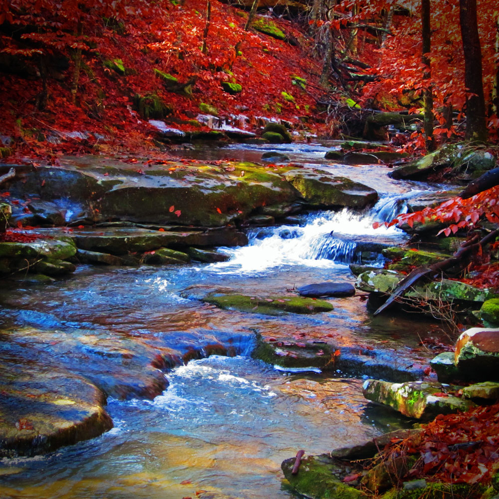 As I descended further down into the canyon, the terrain steepened, with the occasional rock outcropping showing itself through the mixture of hardwood and Pine trees. I then noticed a small drainage that contained a combination of rock, leaves and gravel with several small waterfalls running over a limestone shelf. This drainage continued to swing from left to right before finally emptying into the much bigger Dismal Creek.
Dismal Creek flowed around large boulders, downed trees and over rock shelves that created small waterfalls ranging from 2-4 feet in height. I began to follow the creek downstream which weaved its way into a canyon that gave birth to several large bluff lines that continually squeezed the creek. These bluff lines contained some lovely shelters, overhangs, and great cracks to explore, climb and appreciate.
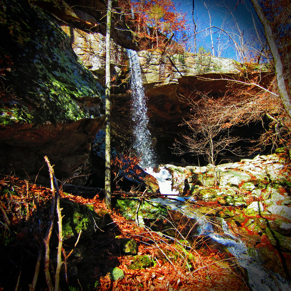
 While continuing downstream, the sound of rushing water caught my attention, but I could not ascertain the source. I continued to absorb the views when suddenly the creek disappeared in front of me and cascaded over a bluff that spanned the entire width of the creek. I quickly moved around to the side and scrambled a few feet up the hillside to get a better view of a beautiful waterfall that cascaded some 40-50 feet into the canyon.
 The bluffs running down each side of Dismal Hollow squeezed and choked the creek at this point, not only creating a beautiful area, but also making it difficult for me to find a way to continue to follow the creek downstream. I then crossed the creek and found a ledge that was about 6 feet wide along the bluff line and followed it downstream, until I found a secondary spot that gave me a better vantage to climb down the bluff to the bottom of the canyon. It was wet, and the limestone was partially covered in mud, leaves and debris, so it forced me to be extra careful.
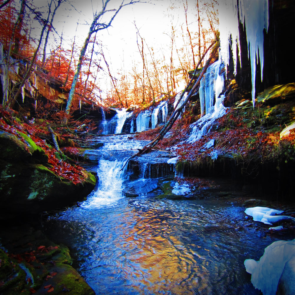
When I finally reached the bottom, I walked back upstream to get a better view of the waterfall and the steep canyon walls. Because of colder temperatures in the immediately preceding weeks, huge and stunning icicles had formed along the bluffs and around the waterfall giving the entire area a magical feel. The combination of the ice, early morning sun, color of the leaves against the green moss covering the rocks and the sound of the water combined for a true feeling of being in a wild and rugged area that only Mother Nature can provide.
 After forcing myself to leave this wonderful place, I continued to follow the creek downstream and encountered steep and rugged terrain. I had to cross the creek several times to avoid being boxed in by steep bluffs. Boulders the size of vehicles and houses lined the banks of Dismal Creek and created the drop for several smaller waterfalls and yet more areas to explore.
Eventually, I made my way to the Little Buffalo River and found a great camping spot underneath a grove of mature Pine trees. While setting up camp in this spot, I could smell the aroma of the Pine trees and listened to the combined sounds of wind blowing through the tops of the trees and those coming from the Little Buffalo River. It fulfilled the purpose of exploring and bushwhacking and was just a perfect feeling.
While this area is wild, rugged and devoid of trails and markings, if you are physically fit and have good navigation skills this is a great place to experience much of what the Ozarks has to offer and is far from being dismal.
Gaining access to the parking area is easy. From Nail, Arkansas, travel west on Arkansas 16 and upon approaching the west end of Nail, look for a county gravel road that travels north and is located on a left hand curve on Highway 16. Take this county gravel road north from Arkansas 16 and look for a pull off area on the left side of the roadway. There have been issues in the past with property owners in the area, so try not to park along the roadway and park in the pull off area.

About Dan:
Dan Nash founded Hiking the Ozarks in 2007, after spending most of his life in the outdoors, backpacking, hiking, rock climbing and camping. As the CEO, Dan coordinates the various programs offered by Hiking the Ozarks, along with instructing various outdoor education classes, participating in the guiding program and testing and reviewing gear for various outdoor companies and places like the Gear Institute, Backpackers Review and Backpacker Magazine. Dan is also the founder of Satori Adventures and Expeditions, a provider of adventures around the world, which include high altitude climbing, trekking, backpacking, rock climbing and cultural exploration in some of the world’s most rugged, wild and unique places. Dan has backpacked, climbed and guided on 5 continents and in both the Himalaya and Ande ranges. Dan is certified as a Level III Backpacking Guide through the Professional Hiking Guides Association (PHGA), along with being on the board of directors for the PHGA.
(Photography for this article furnished by Dan Nash)
