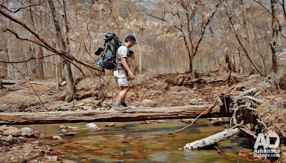


Arkansas is nicknamed The Natural State for its abundance of unspoiled wilderness and scenic beauty. Beyond the well-known state parks, Arkansas offers countless public hiking trails managed by national forests, national parks, and other agencies. These trails lead to towering bluffs, hidden waterfalls, and sweeping mountain vistas. Below are some of the top hiking trails in Arkansas outside of the state park system, with details on their difficulty, length, trailhead access, highlights, water sources, and camping availability. This guide will help you plan an adventure off the beaten path while staying safe and prepared on Arkansas’s premier trails.
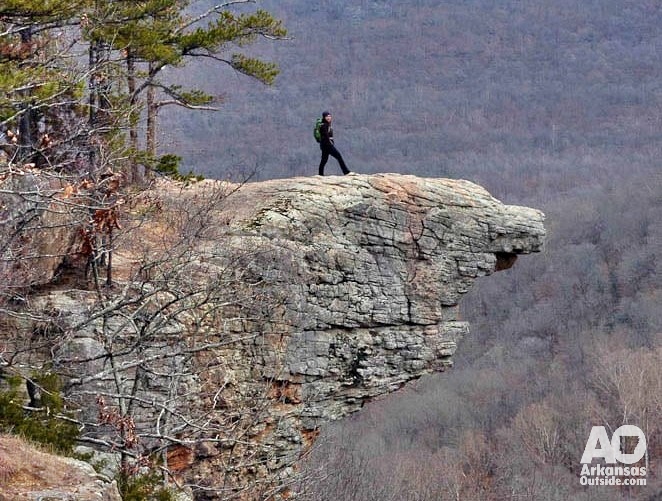
Whitaker Point (Hawksbill Crag) – Ozark National Forest
Length: 2.9 miles round-trip (out-and-back)
Difficulty: Moderate
Trailhead: Near Ponca, Newton County – access via a rugged dirt road off Highway 21.
Whitaker Point Trail leads to one of Arkansas’s most iconic overlooks, a rock outcrop known as Hawksbill Crag that juts dramatically from a bluff over the Buffalo River headwaters. This short hike packs a big payoff: the Whitaker Point vista offers a panoramic view of the Ozark Mountains and is a favorite spot for photographs at sunrise and sunset. Along the way, the shaded dirt path winds through oak-hickory forest and crosses a wet-weather creek. In spring, wildflowers bloom along the trail and a small side cascade (Haley Falls) flows over the limestone ledges after rain. The trail is well-worn but has some rocky, uneven sections. There are no facilities at the trailhead – no bathrooms or water – and parking is limited, so arrive early. A high-clearance vehicle is recommended due to the rough access road.
Water: There are no reliable water sources on this 3-mile hike except occasional creek flow in wet seasons, so hikers should bring plenty of water for the trip. The waterfall near the trail is seasonal and not a year-round water source.
Camping: Whitaker Point is typically done as a day hike. Camping is not established on the trail itself, and camping at the Whitaker Point site is discouraged to preserve the area. However, dispersed camping is allowed in the Ozark National Forest nearby for those on extended trips – campers should set up at least 200 feet from the trail. The closest developed camping options are along the Buffalo National River in Ponca or Steele Creek.
Centerpoint to Big Bluff (Goat Trail) – Buffalo National River
Length: 5.9 miles round-trip (out-and-back)
Difficulty: Moderate, with a strenuous uphill return
Trailhead: Centerpoint Trailhead on Highway 43 near Compton.
This hike along the Centerpoint Trail leads to Big Bluff, often called Goat Bluff, a towering limestone cliff overlooking the Buffalo National River. Big Bluff is famed as the tallest sheer bluff face between the Rocky and Appalachian Mountains, and the trail’s endpoint offers a breathtaking view from a narrow ledge about 500 feet above the river. Hikers begin on an old wagon road through hardwood forest; the first few miles are a gradual descent with little scenery aside from wooded hollows and the occasional glimpse of ridge tops. After roughly 2.5 miles, a side path – the Goat Trail, splits off to traverse along Big Bluff. This final stretch is the most spectacular and most precarious: the ledge narrows in spots with steep drop-offs, so caution is essential. The expansive vista of the Buffalo River valley below is the ultimate reward. Wildlife like elk or feral goats (for which Goat Trail is named) are sometimes spotted in the area’s rugged terrain.
Water: There are no dependable water sources directly along the Centerpoint or Goat Trail. Small crevices on Big Bluff sometimes hold rainwater seeps, but these are not reliable. Plan to carry adequate water, especially since you’ll be hiking back uphill about 3 miles. The climb out gains over 1,000 feet of elevation, and hikers often underestimate how strenuous the return can be in warm weather – hydrate and rest as needed.
Camping: The trail is within the Buffalo National River park, where backcountry camping is allowed with minimal restrictions. While there are no official campgrounds along the Centerpoint Trail itself, experienced backpackers sometimes continue past Big Bluff to reach the river’s edge and camp on gravel bars or designated sites along the Buffalo. (Hikers can access Hemmed-In Hollow Falls on a short hike from the river.) If you choose to camp, you must hike an additional mile down a very steep, unmaintained spur to reach the river (and remember it will be a tough climb back up). For most, Big Bluff is a day hike. Nearby, the Steel Creek Campground (NPS-operated) near Ponca offers developed camping by the Buffalo River if you need a basecamp.
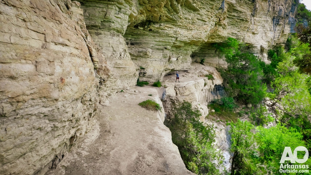
Hemmed-In Hollow Falls – Buffalo National River
Length: 5 miles round-trip (out-and-back)
Difficulty: Challenging, with steep elevation change
Trailhead: Compton Trailhead near Compton, AR.
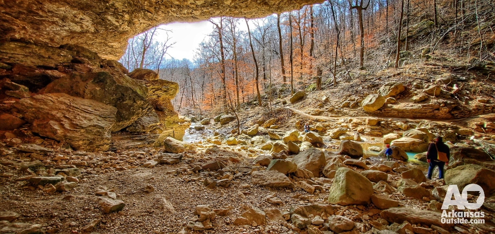
Hemmed-In Hollow is home to a spectacular waterfall hidden deep in a canyon at ~209 feet high, it’s the tallest waterfall between the Rockies and the Appalachians. Reaching this natural wonder on foot requires a demanding hike. The trail plunges more than 1,200 feet down into Hemmed-In Hollow, which means a steep and steady climb back up. The route begins on a wooded ridge and quickly descends via switchbacks into a shady gorge lined with bluffs. As you approach the hollow, you’ll start to hear (after rainfall) the roar of the falls long before you see it. At trail’s end, Hemmed-In Hollow Falls spills in a free drop over a towering rock overhang into a sheltered pool. The sheer sandstone amphitheater draped in moss and ferns makes for a breathtaking, cool oasis and a great spot to rest before the arduous return hike. Hikers should be in good shape and start early to allow plenty of time – the average round-trip time is 4–6 hours due to the elevation change.
Water: The waterfall and creek in Hemmed-In Hollow are seasonal. During wet spring months, water is plentiful – the falls can be a thundering cascade, and the creek flows into the Buffalo River. However, by mid-summer or in dry spells, the falls might dwindle to a trickle or dry up entirely. Do not count on filtering water here year-round. It’s best to carry at least 2 liters per person. In cooler months or if water is flowing, you can treat water from the creek near the falls for refills. Remember that the entire hike out is uphill – pace yourself and hydrate to avoid heat exhaustion.
Camping: Camping is permitted in the Buffalo National River backcountry, so a fit hiker could turn this into an overnight trip, but there are no developed campsites in Hemmed-In Hollow. If camping, select an existing impacted site away from the immediate falls area and at least 1/4 mile from the water source. Many hikers simply visit as a day hike. Another option is to access Hemmed-In Hollow by river: paddlers on the Buffalo can pull in and hike a shorter 0.5-mile trail from the riverbank. This is popular in summer and avoids the big climb, but requires a float trip. For overnight hikers, an interesting loop can be made by combining the Hemmed-In Hollow trail with the nearby Sneeds Creek trail – which passes an old log cabin – and camping near the Buffalo River (check park maps for routes).
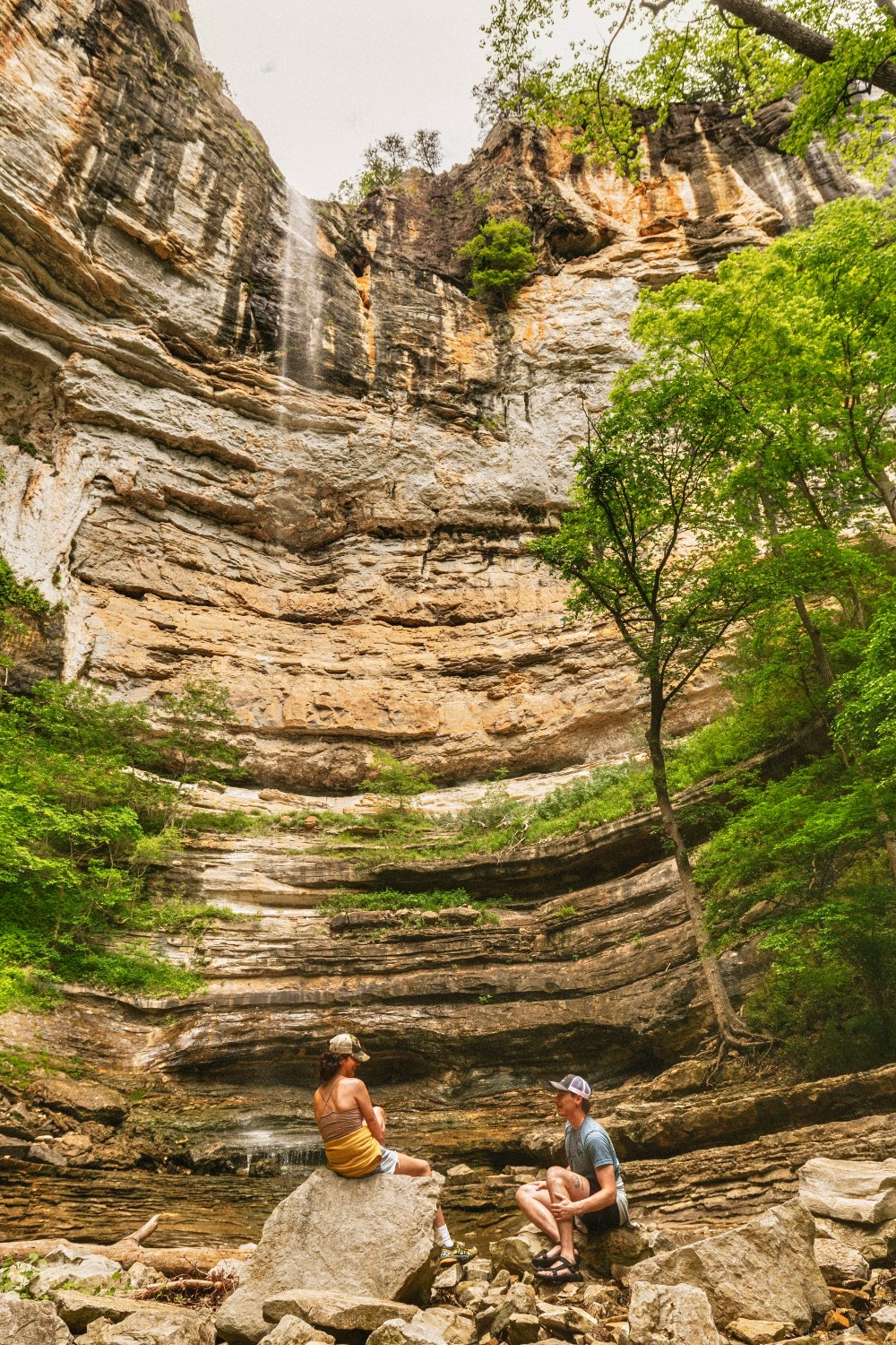
Lost Valley Trail – Buffalo National River
Length: 2.2 miles round-trip (out-and-back)
Difficulty: Easy to Moderate
Trailhead: Off Highway 43 near Ponca.
The Lost Valley Trail is one of the most popular hiking trails in Arkansas, and for good reason. Located in the upper Buffalo National River area, this trail squeezes a lot of scenery into a short distance. The first section follows Clark Creek through a wide, shaded valley with interpretive signs and benches. This portion is nearly flat and was improved to be wheelchair- and stroller-accessible. After about 0.5 mile, the paved path gives way to a dirt and rock trail as the canyon narrows. The second half is a steeper climb on stone steps and switchbacks as you venture deeper into Lost Valley. Highlights include Cobb Cave, a huge bluff shelter, and finally Eden Falls, a picturesque 53-foot waterfall tumbling over a limestone cliff. Adventurous hikers can even scramble up into Eden Falls Cave just above the falls: this 200-foot cave contains an underground waterfall in its final chamber. (Bring a flashlight if you plan to explore the cave, and exercise caution on the slick rocks.) Please remember, no dogs are allowed on the trail.
Water: Clark Creek is a seasonal stream that runs alongside the trail, so you may see pools and small falls especially during spring and after rains. In wetter periods, water is abundant (and the scenery is best when the waterfalls are flowing). In dry summer months, parts of the creek bed may be dry. Because the hike is short, most visitors bring a water bottle from home. If needed, creek water can be filtered, but be aware it may not flow in late summer. Do not drink directly from the creek due to possible contaminants – always treat water from natural sources. There is no potable water faucet at the trailhead, so fill up before arriving.
Camping: Camping along the trail itself is not allowed since Lost Valley is a day-use area that sees heavy traffic. Consider camping at nearby Steel Creek or Kyle’s Landing campgrounds along the Buffalo River, just a short drive away, to explore the region.
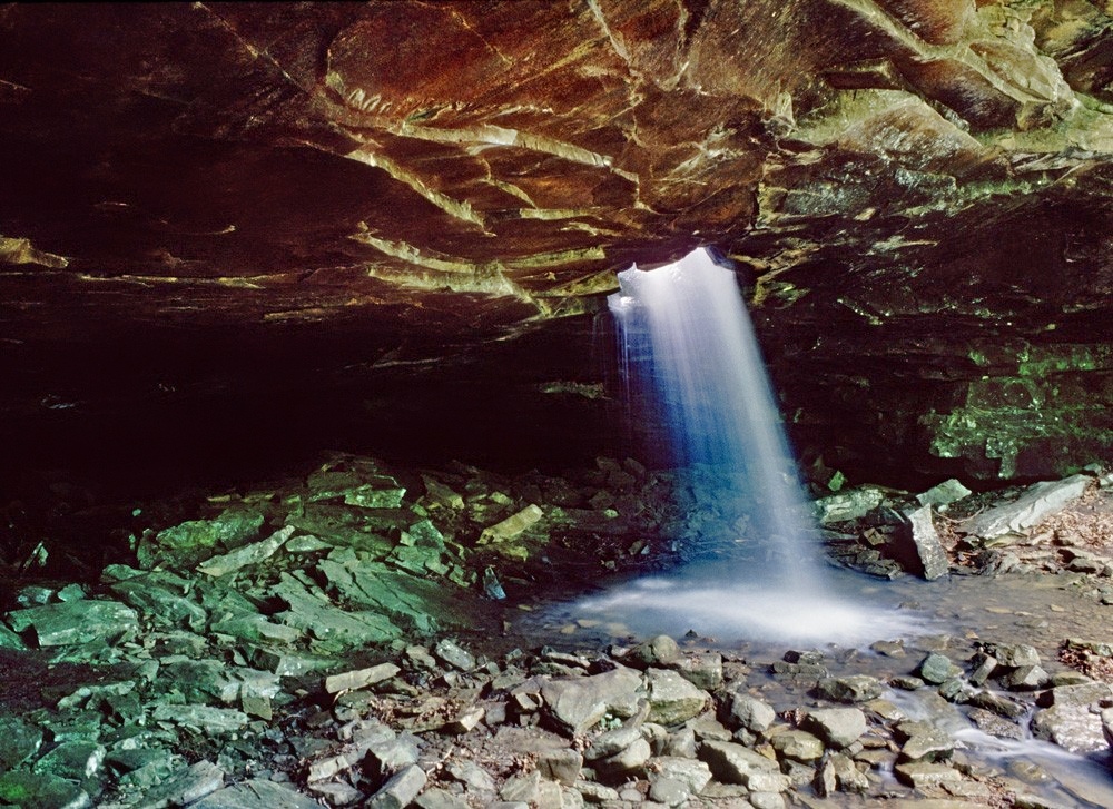
Glory Hole Falls Trail – Ozark National Forest
Length: 2 miles round-trip (out-and-back)
Difficulty: Moderate
Trailhead: Highway 16 between Fallsville and Deer.
The Glory Hole Falls Trail is a unique gem of the Ozarks. This brief hike leads to an unusual waterfall where a stream has drilled a circular hole through a solid rock shelf, creating a shower of water into a cavern below. The trail is relatively short, but note that over half of the distance is downhill on the way in – meaning the hike back out is mostly uphill. Starting from the roadside, the path descends gradually through pine-hardwood forest and then follows an old Jeep road into a rocky hollow. After rains, you’ll hear Dismal Creek flowing alongside; several smaller cascades appear as you approach the main attraction. The Glory Hole waterfall itself drops about 30 feet through the round opening of an overhanging rock ledge. Visitors can view it from above, where the creek water swirls and disappears into the stone, and then carefully scramble down to see it emerge in the grotto below. It’s an otherworldly sight and a favorite for photographers. Kids love this hike for its “wow” factor, though close supervision is advised around the slippery rocks near the falls.
Water: Dismal Creek feeds the falls and usually flows in winter and spring. In a rainy season, the creek will be lively and the Glory Hole pours a substantial stream of water (and you might even get misted in the cavern). However, in dry periods the falls can slow to a drip. As a water source, the creek is present in the lower hollow, but it’s recommended to bring your own water for this short hike. The uphill return, while only a mile, can be surprisingly tiring in summer heat, so carry enough to stay hydrated. Treat any creek water if you do collect it.
Camping: There are no official campsites on the Glory Hole trail. Camping is allowed in Ozark National Forest generally, but this particular spot is often busy with day hikers and has limited flat ground. It’s best enjoyed as a day hike. Always practice Leave No Trace if camping in undesignated areas.
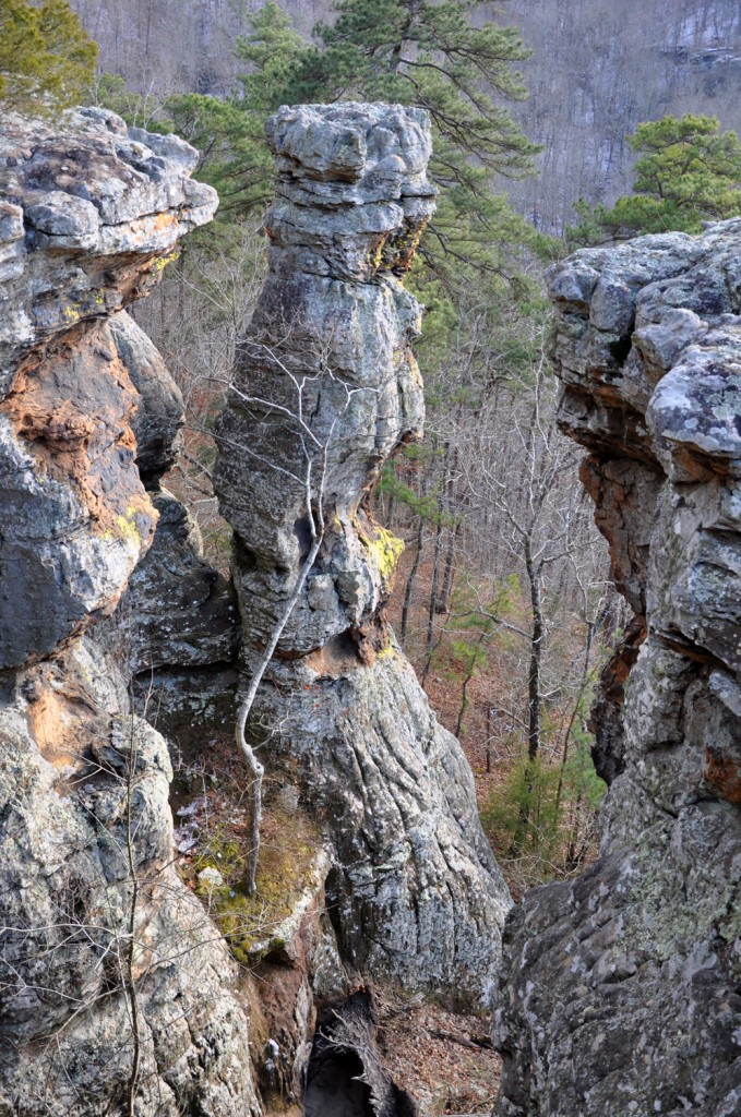
Pedestal Rocks & King’s Bluff Trails – Ozark National Forest
Length: 2.5-mile loop (Pedestal Rocks), 1.7-mile loop (King’s Bluff)
Difficulty: Moderate
Trailhead: Pedestal Rocks Scenic Area on Highway 16 near Pelsor.
This location offers two rewarding loop trails from the same trailhead, each showcasing unique geological features. The Pedestal Rocks Loop (2.5 mi) winds through the woods to a series of massive free-standing rock columns, formations that resemble giant stone pedestals rising from the valley floor. The trail follows along the bluff line where you can look down on these intriguing rock spires. A short side scramble allows hikers to climb below the bluff to explore slots, caves and natural arches among the pedestals for an up-close perspective. It’s like nature’s sculpture garden hidden in the forest. Adjoining this, the King’s Bluff Loop (1.9 mi) leads to a broad rock ledge with panoramic views and features a seasonal waterfall spilling over the bluff. King’s Bluff waterfall, when flowing after rain, drops over 100 feet off the ledge – an impressive sight in wetter months (though it may be dry in summer). Even without the waterfall, King’s Bluff provides stunning vistas of the Ozark highlands and interesting craggy rock formations along the trail. Both loops are relatively short and family-friendly, with moderate elevation change and a well-maintained path.
Water: These trails traverse upland forest and bluff edges where water is scarce. The only water feature is the King’s Bluff falls, which is a wet-weather waterfall. After recent rainfall you might find streams near the bluffs or water seeping over rocks, but in dry conditions there may be no water at all on the trail. Plan to bring your own drinking water. The trailhead does not have a water pump. There is a picnic area and vault toilet at the parking area for your convenience, but no potable water provided.
Camping: The Pedestal Rocks Scenic Area is intended for day use, and camping at the trailhead or along the loops is not officially permitted. The parking area is patrolled, and overnight parking is generally not allowed except by permission. That said, the surrounding Ozark National Forest land does allow dispersed camping. If you wish to camp, you could find a spot off a nearby forestry road (well away from the scenic area) or use a designated campground. By camping elsewhere, you can hike Pedestal Rocks early in the morning for solitude. Always pack out all trash and be mindful of private property boundaries outside the designated area.
Eagle Rock Loop – Ouachita National Forest

Length: 26–28 miles loop
Difficulty: Strenuous
Trailhead: Multiple, including Little Missouri Falls and Winding Stairs.
For a true backcountry adventure in Arkansas, the Eagle Rock Loop is the ultimate challenge. This epic loop combines three trails – the Little Missouri, Viles Branch, and Athens-Big Fork West trails – into the state’s longest and perhaps most demanding circuit hike. Over roughly 26 miles, hikers will climb up and over six separate mountains in the Ouachitas (with around 4,000 feet of total elevation gain). The reward for all that effort is continuous scenery: crystal-clear streams, cascading waterfalls, rugged ridges and serene mountain vistas. The route forms a loop through the Ouachita National Forest’s lush hardwood and pine woods. A few highlights include crossing the Little Missouri River multiple times, passing the cascading Little Missouri Falls, trekking through the picturesque Winding Stairs area (a scenic gorge with turquoise pools great for a summer swim), and camping under the stars in remote valleys. Wildlife is abundant – you might glimpse deer, wild turkeys, or even signs of black bear along the trail. Eagle Rock Loop is typically hiked over two to three days, though very fit individuals have trail-run or hiked it in a single day. Most people will want to pack a tent and take their time soaking in the natural beauty.
Water: One thing that sets Eagle Rock Loop apart is plentiful water availability. Numerous streams and the Little Missouri River crisscross the loop, so hikers can filter water at many points. In fact, you’ll wade through water frequently, there are at least half a dozen major water crossings (without bridges), so prepare to get your feet wet. Always check conditions; after heavy rain, some crossings can be dangerous due to high water or flash floods. The tragic 2010 flash flood at the now-closed Albert Pike Campground is a reminder to avoid camping in low river valleys if storms are expected. Carry a map and note where reliable water sources are, but in normal conditions you will not need to carry more than 1–2 liters at a time, refilling as needed from streams (using a filter or purification tablets). Treat all surface water, as livestock and wildlife could introduce contaminants upstream.
Camping: Backcountry camping is allowed throughout the loop, and there are many established primitive sites used by hikers. Pick a durable, flat spot at least 200 feet from water sources. There are no fees or permits required. Campers often do a two-night trip, dividing the mileage into roughly 8–10 miles per day. Bear in mind there are no bear canisters required here, but practicing safe food storage (hanging a food bag or using a bear-proof canister) is wise due to the presence of black bears in the Ouachitas. Most Eagle Rock Loop hikers camp in the backcountry. Come prepared with a map, compass/GPS, and good boots – this loop is remote and receives only moderate foot traffic, providing a true wilderness experience in Arkansas.
Rattlesnake Ridge – Ouachita Mountains
Length: ~3.5 miles of interconnected trails
Difficulty: Moderate
Trailhead: Barrett Road, Roland, AR, just west of Pinnacle Mountain.
For hikers near Central Arkansas, Rattlesnake Ridge Natural Area offers a wild escape just outside the city. This 373-acre protected area is managed by the Arkansas Natural Heritage Commission and features a rugged ridge with sweeping views. The Cliffbrake Trail and other interconnected routes form about a 3 to 4 mile network winding up to the ridge’s summit (~920 feet elevation) and along rocky bluffs. The hike to the top is a steady climb through cedar glades and stands of shortleaf pine, with some switchbacks and a bit of rock scrambling near the peak. At the summit, hikers are rewarded with panoramic views of the Ouachita Mountains, including a striking look at nearby Pinnacle Mountain and the valleys of the Big Maumelle and Little Maumelle Rivers. Rattlesnake Ridge’s geology is unique, the area is a rare sandstone outcrop barren, creating habitat more common to deserts further west. Keep an eye out for interesting plant life like yucca and cactus growing on the sunny, rocky slopes. The ridge gets its name not just from its shape but also from its inhabitants: the western diamondback rattlesnake is known to live here (one of the few places this species is found in Arkansas). Encounters are infrequent, but it’s wise to watch your step and not reach blindly under rocks or ledges. Non-venomous snakes, lizards and a variety of birds also thrive in this protected haven.

Water: There are no water sources available on Rattlesnake Ridge’s trails. The natural area’s terrain is dry and drains quickly. Hikers should bring their own water – at least a liter for a short outing, more on hot summer days. The trailhead has no water fountain, and the parking lot is primitive (just a gravel area with a gate). Plan accordingly, especially since the exposed ridgetop can get very hot under the sun.
Camping: No camping is allowed at Rattlesnake Ridge Natural Area. The area closes at dusk, with a gate that is locked each evening (vehicles left inside will be locked in). This is strictly a day-use trail system. If you’re looking to camp nearby, the Maumelle Park campground is a short drive away. Otherwise, Rattlesnake Ridge is perfect for a morning or afternoon hike to grab some great views and be back in Little Rock in time for dinner. It’s a lesser-known spot that provides a taste of true Arkansas wilderness just minutes from the suburbs, combining conservation of rare species with low-impact public recreation.
This article was originally published on ArkansasOutside.com, your trusted source for outdoor news and updates in The Natural State. Unless otherwise credited, all photos included in this piece are the property of Arkansas Outside, LLC. We take pride in sharing the beauty and adventures of Arkansas through our lens—thank you for supporting our work!