


This is the third part in our series on completing the Arkansas River Trail in Little Rock.
In our first installment, we told you WHAT Closing the Loop means. Our second installment brought you a list showing HOW local leaders and advocates have attempted to Close the Loop. This article will attempt to describe WHY the City of Little Rock needs to Close the Loop.
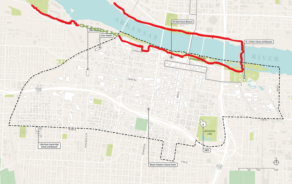
Completing the Arkansas River Trail near Dillard’s Headquarters in Little Rock is important for several general reasons:
Safety and Connectivity:
- Gap in the Loop: Currently, the trail has a significant gap near Dillard’s, forcing users onto busy streets and sidewalks. Completing the section would create a seamless loop, improving safety and convenience for cyclists and pedestrians.
- Missing Link: The Arkansas River Trail is envisioned as a major recreational and transportation artery through Little Rock. Filling the gap would connect important destinations like the River Market and Two Rivers Park, and allow users to avoid traffic congestion.
Economic Development:
- Enhanced Accessibility: A complete trail would increase accessibility to businesses and attractions near Dillard’s, potentially boosting economic activity in the area.
- Attractiveness for Residents and Tourists: A fully connected trail system is a major selling point for both residents and tourists, making Little Rock a more attractive place to live and visit.
Environmental Benefits:
- Reduces Car Dependence: A comprehensive trail system encourages alternative transportation, reducing air pollution and traffic congestion.
- Promotes Public Health: The trail provides opportunities for exercise and outdoor recreation, contributing to the physical and mental well-being of the community.
Renewed Importance
It’s important not to ignore the incomplete section of the Arkansas River Trail because doing so can have negative consequences on both local and regional planning in central Arkansas. The Arkansas River Trail needs to be safe and fully functional to support various ongoing projects that rely on it. These projects are currently being funded by millions of dollars from both public and private sectors.
Maumelle Pinnacles Initiative – According to the plan website, “The Maumelle Pinnacles Conservation Area has a wide-ranging spectrum of recreation types, some resembling city parks in urbanized areas and others serving a more secluded and natural recreation role. This plan seeks to connect these many parks, conservation areas, and trailheads with an equally diverse system of pathways. Mountain bike trails, paved bike and pedestrian trails, soft surface trails, and even the 223-mile long Ouachita Trail are all different types of recreation amenities, and even serve as connecting corridors between some destinations.”

Katherine Andrews, Director of the Arkansas Office of Outdoor Recreation said, “The Arkansas River Trail provides an avenue to some of our state’s most beautiful natural areas. Connecting the River Trail to the broader vision in the Maumelle Pinnacles Conservation Area Master Plan will further draw people from the hustle and bustle of downtown Little Rock to a serene adventure in nature.”
You can read more about this initiative in our article from December of 2023.
Downtown Little Rock Partnership Master Plan – The master plan website states, “The Downtown Little Rock Master Plan is the first of its kind planning effort for Downtown Little Rock to create a strategic vision for growth and development in order to create a better future for downtown and its users. Additionally, the vision will provide enhanced connections to the rest of the city, creating a quality public realm and increasing quality of life for residents, workers and visitors.” (bold for emphasis)
Gabe Holmstrom, Executive Director of the Downtown Little Rock Partnership, said, “The Arkansas River, and by extension the Arkansas River Trail, has the potential to be the backbone for outdoor recreation in Central Arkansas. Improving connectivity and reorienting the city to the river through new development is a central tenet of the Downtown Master Plan and will be essential in driving Little Rock’s future success. Mother nature provided an incredible amenity, but we must increase access to the river to harness its full potential.”
There are two designated corridors for bicycle traffic to enter this area from the west, the 12th Street bike lanes and the Arkansas River Trail.
Southwest and Southeast Trails – The Southwest Trail summary sheet says, “Pulaski, Saline, and Garland Counties are working to develop a trail to connect to Hot Springs National Park, the Old River Bridge on the Saline River, the Little Rock Central High School Historic Site, and the Arkansas River Trail System that allows for pedestrians and bicyclists to safely enjoy outdoor recreation while providing an economic stimulus to the local and regional economies.”

Pulaski County Judge Barry Hyde, responsible for planning and construction of the Southwest and Southeast Trails in Pulaski County, said, “The River Trail is absolutely the core of The Central Arkansas Regional Trail system. Not only for branches into the community but also for the Southwest, southeast and the new trails coming in from the north, west, east and northeast.”
You can read the latest update on construction and planning for the Southwest Trail in our article from May of 2023.
MetroPlan’s Regional Greenway Initiative – According to MetroPlan’s website, “This planning study outlines future paved bicycle and pedestrian paths and trails, called greenways, to connect Faulkner, Lonoke, Pulaski, and Saline Counties. Metroplan, the region’s planning organization, dedicated substantial funding to construct greenways that increase local and regional connectivity and mobility, while fostering economic development, quality of life, and recreation opportunities.”

MetroPlan Executive Director, Casey Covington, reiterated the important connections that the Arkansas River Trail makes between other trails and projects, “Since the Arkansas River Trail’s inception, the multi-use trail network has been a key part of providing transportation choice while also increasing recreation opportunities in Central Arkansas. The Central Arkansas Greenways system will expand the Arkansas River Trail’s utility by linking additional communities throughout the region to a multitude of new trails. Completing and extending the Arkansas River Trail, including an extension to the Maumelle Pinnacles Area, is critical to the livability and economic growth of central Arkansas.”
Read more about MetroPlan’s Regional Greenway Initiative in our article from July of 2023.
The Little Rock Master Street Plan – From the forward to the bike plan portion of the 2018 Little Rock Master Street Plan, “It is the City’s intention to provide bicycle accessibility throughout Little Rock. This can be accomplished with the use of the existing street network, with additional bicycle paths and lanes where necessary for safety and continuity. In addition to the existing street network, the City of Little Rock has adopted a network of routes to be specially designated for bicycle use. This Plan provides a system of Classes, (see table below). It is the purpose of the City of Little Rock to review these routes on a regular basis to determine the need of upgrading the routes, and to review the need for additional routes. The decision to upgrade the routes will be based on usage, safety and speed and volume of motorized vehicular traffic.”
“All bicyclists wish to have safe, direct routes for non-recreational trips. The most advanced riders can generally operate under most traffic conditions. However the more casual user often will feel
intimidated by the vehicular traffic. This combined with high volume and high speed vehicular traffic and few direct routes available creates the need for a bicycle route system desirable for all users.”
According to John Landosky, Little Rock Bike/Pedestrian Coordinator, “Did you know that even though only 3% of Little Rock residents report using their bike for their regular commute, 19% of those same respondents would LIKE to use their bike for that commute? Why don’t they? The top reason is a lack of bicycle facilities. An on-street bike network is critical to make connections, but when it comes to encouraging people to make a 5+ mile commute, nothing is more impactful than an off-street trail. We have a lot of plans for shared-use paths useful for transportation, but right now, the Arkansas River Trail is the only trail that is built. The Complete Streets: Bicycle Plan calls for connectivity TO the ART so that the ART can be leveraged for transportation, but those connections will only be useful if the Arkansas River Trail itself is complete.”
Completing the Arkansas River Trail near Dillard’s is not just a matter of filling a gap in the path, but rather a key element in creating a more connected, healthy, and vibrant Little Rock.
It is undeniable that the Arkansas River Trail needs to be completed to ensure safety for pedestrians and bicyclists using it for transportation and leisure activities. The City of Little Rock should prioritize this matter. A completed river trail would not only be beneficial for the people but also serve as an economic engine for the region. Unfortunately, the city has had more than 20 years to address this issue, and yet it remains unresolved, with the blame being shifted to business owners in the area. Ultimately, we voted for our city leaders and it is their responsibility to ensure that this matter is resolved. The reasons for this delay are not financial or economic, but rather political. As citizens, we deserve better.

Getting Involved
If you are interested in getting involved in closing the loop and completing the Arkansas River Trail, here are some ideas:
- For citizens of Little Rock – Contact Mayor Frank Scott’s office, your city ward director, the ward 1 director (where the gap exists), and all at-large ward directors. Also, contact those listed below. You can find your city ward director here: https://www.littlerock.gov/city-administration/board-of-directors/
- For anyone interested – Contact the offices of Representative French Hill, State Senators Clarke Tucker, Fred Love, Linda Chesterfield, and State Representative Tippi McCullough. Also, contact the First Gentleman’s office. Bryan Sanders is the chair of the Natural State Initiative an advisory board that includes Tom Walton and Bill Dillard III among its board.

5 Responses
The Metro plan Greenway link was the only source of information for things going on in North Little Rock, Sherwood Jacksonville. On that Greenway map I was discouraged to see a huge gap between the northernmost reaches of a planned trail in North Little Rock and the southernmost reaches of a planned Greenway Trail in Sherwood. This will leave people having to meander their way through neighborhoods to get from one point to the other. Having ridden in those areas myself, it is doable, but it means being on roads. And this area is becoming more and more congested making it more and more challenging.
As such these plans will really do more to support Central Arkansas to the south and into the north west and nothing to the north east
The huge gap in Sherwood is “under further review”. There were potential routes on older maps, but there are pros and cons for each route, hence the need for more studies. I’m pretty sure the plan is not to leave the gap.
Joe,
This is so vital, to first finish the loop. You lead the way with all this incredible information. I was on the first close the loop campaign and all this info was not available. So glad you have made this available to everyone. Steve Bentley is planning to rally the troops again and get this important section linked. Any way I can help, let me know. It’s going to happen, the sooner the better.
Close The Loop is coming back in a big way. We were successful in being an active part in the completion of Big Dam Bridge and the Clinton Bridge. We will be successful again. Stay tuned for future meetings to be announced by Joe Jacobs as we get laser focused to push results!
As a cyclist Dillard’s needs take into consideration and understand that the path under Cantrell bridge this is not a safe place for a road and should be used for people who ride a bike, especially my type of bike. the Dillard’s route is a real maze and an accident looking to happen. I use the route under the Cantrell bridge and go up the Episcopal sidewalk for safety to reach my bike group that meets at Clinton and the Big Dam Bridge and Tour De Rock bike events which are usually early in the mornings and Shift Modern Cyclery. Taking the Dillard’s route would be hard to navigate that early in the morning even with bike lights. The sidewalks on Dillard’s route are too narrow and curve in and out.
I take the Arkansas River Trail that leads, under the Cantrell bridge and along the Episcopal sidewalk a lot and it is very inconvenient and unsafe for bikers. It is my understanding that Dillard’s has some land that could make this bike trail safer for people who use this route under the Cantrell bridge and along the Episcopal sidewalk, but they have refused to give it up. Dillard’s is not cooperating and is making things very difficult. In conclusion, it is up to the city and businesses like Dillard’s to fix this mess.